


Overview
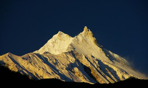
If you would like to sample both extremes of the trekking experience in Nepal, and really get to see what all the fuss is about in terms of the most breath-taking mountain scenery on earth, then look no further than the circuit of Manaslu via the Larkya La.
The Tibetan enclave of Nupri, north of Manaslu at the head of the Budi Gandaki, was closed to foreigners for years on account of its proximity to Tibet. The area was surreptitiously opened in 1991, but it took several years for the word to get out.
The trail circumvent interesting Manaslu peak [8163m.] crossing Larkya pass at 5100 meter and finally emerges onto the Marshyangdi river valley along the main trail of Annapurna circuit. You will have two options as where to conclude your trek.
Highlights of the Trekking
Trekking through beautiful village including Samagaon, samdo as well as Gandaki and Marsyangdi valley, Visit ancient monastery in Samagaon, Larkya La bazaar, exploring around aqua-blue green lake Birendra and crossing snow covered high pass Larkya La.
Details Itinerary
DAY 01 ARRIVAL IN KATHMANDU
Upon arrival at Tribhuwan International airport in Kathmandu meet our airport representative and transfer to the hotel .Overnight at Kathmandu .
Day 02: KATHMANDU SIGHTSEEING
In the morning after breakfast full day sightseeing tour of Kathmandu , the most popular Place in the kingdom was known as kantipur in earlier times. The tour highlights are the Living Goddess " Kumari" who appear on the balcony of her temple to greet her devotees; Kastamandap temple, the temple made out of single tree and name Kathmandu is derived from durbar square and drive to Swayambhunath which lies on top of hill is the Buddhist sanctuary said to be nearly 2000 years old. The hill itself is pleasant place overlooking the entire valley of Kathmandu . The all seeing eyes of Lord Buddha painted in prominent blue atop the dome are visible from long distance from around the Kathamandu city
DAY 03 DRIVE TO ARUGHAT BAZAAR
we drive along the Kathmandu-Pokhara Highway for the first part of the day; we turn of towards to the hill bazaar of Gorkha. After Gorkha the road gets a bit rough but we will reach our destination Arughat Bazaar in approximately seven hours from Kathmandu .
DAY 04 TREK TO SUNDI KHOLA
on our first day on the trail we head north, following the Budhi Gandaki. In the low country rice paddies and picturesque hamlets surround us. After climbing briefly to Kyoropani, we descend once again to the river and our campsite at the confluence with the tributary of Sundi Khola. It is a nice first day not too long, and perhaps we have time for a refreshing swim sometime during the day for it is hot in the low country.
DAY 05 MACHHA KHOLA
The country changes, the broad valley narrows and at times the trail is cut into the steep valley side, which is densely forested. We pass a number of small villages, tucked into the hillside, until we reach a widening of the valley, opposite the point where a large tributary stream enters the Budhi Gandaki. The terraced farmland here belongs to the village of Lapbesi . We descend once again to the wide, sandy riverbed and follow a path, which runs below the steep, craggy valley side. At length, we have to climb up once again on a trail to Machha Khola. We camp outside the village, which has a number of teashops.
DAY 06 JAGAT
We cross the Machha Khola - Fish Stream - and head upstream to the tiny village of Khola Bensi and the hot springs at Tatopani. The valley sides are steeping until they are impassable and the route then switches to the left bank by way of a suspension bridge. The trail is quite exposed and challenging in places. After a short section of forest path we reach the single teahouse at Doban. Above Doban, the Buri Gandaki descends an impressive series of rapids. Beyond this steep section, the river is much more placid, meandering across a broad gravel bed. At Lauri, we recross the river on a suspension bridge, and then climb on a high path to the fields of Jagat, where we camp.
DAY 07 DENG
After descending a long series of stone steps to the river, we climb a terraced hill to Saguleri, from where we can see the impressive Sringi Himal, 7187m. Crossing the river again, at Gata Khola, the path splits, with the right-hand branch heading off towards the Ganesh Himal. Our route continues upstream, through a gorge section with towering walls. We cross the river three more times in the next two hours to avoid difficult valley sides and then climb up over a further steep spur to reach the village of Deng (four houses), where we camp. Today is a longer day of around 7 hours trekking.
DAY 08 GHAP
The valley is still steep-sided and most impressive. We cross to the village of Lana , and start to see mani stones (prayers etched onto wayside rocks), a sure sign that we are entering a the high country Buddhist regions. After only about four hours we reach our camping place at the village of Ghap , which straddles the river. We have entered the Tibetan areas and the cultural change is obvious, and the climate change is also obvious the trekking is pleasantly cool now, as we start to gain the altitude.
DAY 09 LHO VILLAGE
We gain altitude to take us into alpine territory and increasing mountain views. There are more Mani walls and 3 more crossing of the Budhi Gandaki on our route to Namrung, where our special permit is checked. Above this village the valley opens out and there are extensive pastures. Climbing climb gently now, and cross a large stream flowing down from the Lidanda Glaciers, and reach the Tibetan village of Sho, 3000m. We get our first incredible views of the Manaslu North and then of Manaslu main ahead from Sho. As we continue we come to Lho, a large village at 3150 metres where there is a lovely little monastery and numerous chortens and Manis. Looking back Ganesh I is visible. We camp just outside the village.
DAY 10 SAMA GAON
Leaving the village, we follow the right bank of the river, with views of Peak 29 ahead. As we continue on the main trail, we soon reach the fields of Sama Gaon, 3500m. We camp at Sama Gompa, 20 minutes beyond the village, or Samdo, near the Tibetan border.
DAY 11 REST DAY
Surrounded by mountains in a peaceful forest, we take a rest day to acclimatize and relax. It is a good time to catch up on that book or wash clothes.
DAY 12 LARKYA LODGE (DHARAMSALA)
The once large Budhi Gandaki is now merely a stream as we continue to follow its course ever upwards. Everywhere you look are mountains, as spectacular as they get and Manaslu is particularly impressive. After crossing to the East bank of the river, we reach the last permanent settlement in the valley, which is called Sumdu. Above the village we cross the stream, which runs down from the Gya La (Pass), the pass to Tibet , and there is the ruins of another village here known as Larkya Bazaar. Presumably this village thrived on trade with Tibet over the nearby Gya La, a trade that is now much diminished. Nearing the Larkya Glacier, we reach a lodge at 4450m, which has been built to serve the travellers crossing the Larkya La.
DAY 13 TANBUCHE
After a short climb above the lodge; we reach the ablation valley on the North side of the Larkya Glaciers. There are views of Cho Danda and then of Larkya Peak . Finally, we walk across the moraines of the glacier, making a gradual ascent, which becomes steeper only in the last section to the pass. From the pass, there are outstanding views of Himlung Himal, Cheo Himal, Kangguru and the huge Annapurna II. Initially, there is a steep descent over snow and then scree, to reach the ablation valley trail to Larcia Kharka. A further hour on a moraine ridge path leads to Tanbuche 3900m in pleasant forest.
DAY 14 KARCHE
Below us is Bimthang, a broad and level ablation valley with a number of Mani walls and deserted houses. Crossing this high pasture, we descend the valley of the Burdin Khola to the area of the Base Camp for the West side of Manaslu. From a ridge at 4150 metres, we have excellent views of Manaslu to the South East and Annapurna II to the South West. Beyond a bridge over the headwaters of the Dudh Khola, we descend into a rhododendron forests and follow a trail through a narrow valley until we reach the highest cultivated land in this valley at Karche, 2785 metres
DAY 15 BAGARCHAP
We climb through terraced fields to the Karche La (Pass), and can see ahead a green and heavily forested valley, dropping down to the distant Marshyangdi river. At Thonje village is our final restricted area check post. Here we cross the Marsyandi River and join the main Annapurna Circuit, and the hoards of trekkers. We arrive at Bagarchhap, a Bhote village with prayer flags fluttering in the breeze.
DAY 16 CHAME
Today we continue to climb through forests of pine and oak; we pass through Dhanakyu before coming to a thundering waterfall. Further on, the Marsyangdi Khola enters a gorge and the path consists of steep stone steps. Pausing for breath, we can look back for views of Manaslu. When the steep incline ends we follow a path amid magnificent rhododendrons to Ratamron and then continue on a gently rising path, crossing a stream before entering a pine forest. We then cut across a loose hillside to the hamlet of Kotho from where we can look straight up at nearby Annapurna II - a sight convincing us that we are deep in the Himalayan mountains! From here the trail climbs through a fir and pine forest to Chame where there are government offices, shops, and hotels. Chame is the administrative headquarters for the Manang district. This is only a half days trek, we need a day to wash a bit again or maybe just to rest a bit.
DAY 17 PISANG
With Lamjung Himal (6893m) sparkling in the morning sun, we set off for Pisang. The mountain disappears as we climb the path up the valley, passing a huge apple orchard. We continue through a fir and pine forest, climbing to a high, rocky area, as the opposite bank becomes an impassable cliff. From this point the valley becomes extremely steep-sided as we follow the path to Bratang. In the past this was the military station for troops who fought against the Khampa tribal revolution, but the dilapidated buildings are all that remain of that era. A short climb from the village brings us to a rock-strewn area where we cross a wooden bridge and follow a high, winding path, before crossing back to the right bank again. We now walk through a pine forest and as the forest ends, the valley changes from a V-shape to a gentle U-shape, opening up a wonderful vista before us. We can see the east peak of Annapurna II as well as Pisang Peak to the northeast. Continuing on, we come to a long mani wall by a bridge and the lower village of Pisang .
DAY 18 MANANG
Beyond Pisang, the trail climbs a steep ridge, which affords good views of the Manang valley and Tilicho peak. Descending past Manang's airstrip at Hongde, we come to a level area from where the northeast face of Annapurna III rises majestically above us. From the wide plains of the Sabje Khola Valley , Annapurna IV (7525m) also becomes visible. Just beyond this point we cross the considerably reduced flow of the Marsyangdi Khola via a wooden bridge to the tiny village of Mungji . Cultivated fields appear on both sides of the path and off to the right, below a craggy mountain, we can see the village of Bryaga with its splendid monastery. Large chortens and mani walls abound and the tall peaks of the Himalayas spread out before us - Annapurna II, Annapurna III, Annapurna IV, Gangapurna (7455m) and, to the rear, Tilicho Peak (7134m).
After a short steep climb we reach Manang, which is a surprisingly large village for this remote mountain region. We camp here for the night, amidst the fluttering prayer flags, which adorn the houses.
DAY 19 THORUNG PHEDI
From Manang, we climb to the next village of Tengi , with the magnificent Annapurna Himal in view all the way, while behind us we can see Peak 29 and Himalchuli in the distance. We are now past the tree line and the vegetation consists of alpine grasses and scrub juniper. Climbing the path past the summer village of Gunsang , we cross the Gundon Khola via a wooden bridge. From here we can see ahead the mountains surrounding the Thorung La, which we will cross tomorrow. The trail is up and down as the elevation gradually increases and we soon enter an alluvial delta where there are yak pastures. An hour beyond this, we come to the small settlement of Letdar. Leaving Letdar, we climb gradually to a ridge before descending to the headwaters of the Marsyangdi and crossing via a covered wooden bridge. After a short ascent up the mountain path on the right bank, we follow a narrow trail across an unstable scree slope and then descend to Thorung Phedi.
DAY 20 MUKTINATH
An early start today for our crossing of Thorung La (5416m). The trail becomes steep immediately on leaving camp but as this trail has been used by local people for hundreds of years the path is well defined. The gradient then eases and after around 4 hours of steady climbing we reach the chorten and prayer flags of the pass. The views are dramatic to say the least, from the snow covered mountains above, to the head of the Kali Gandaki valley below and the brown and purple hills of Mustang which are spread out before us. The descent to Muktinath is a knee pounding 1600m but it's compensated for with excellent views of Dhaulagiri . Eventually the moraines give way to grassy slopes before a pleasant walk along the Jhong Khola Valley to Muktinath and its shrines and temple.
DAY 21 JOMSOM
We now begin the descent down the dramatic Kali Gandaki valley, initially through arid country in the same geographical and climatic zone as Tibet . After passing through Jharkot and Khingar, villages with typical Tibetan architecture, we follow the valley floor most of the way to Jomsom and are rewarded with tremendous views of both Dhaulagiri and Nilgiri. Jomsom is a large town sprawled along both banks of the Kali Gandaki River , and it is here we will spend the final night of our trek.
DAY 22 Flight from Jomsom - TO - POKHARA
We take an early morning flight to Pokhara. It is a spectacular flight along the Kali Gandaki Gorge and provides wonderful views of both the Dhaulagiri and Annapurna ranges. Upon arrival at Pokhara half day sightseeing tour and Over night at lake side pokhara.
DAY 23: Pokhara City Tour
After breakfast we've sightseeing around Pokhara valley. You're free in Pokhara Valley also called " Magic Land " or Dreamland" of Nepal , to explore the various interesting place like a boating in Fewa Lake over looking the region of Annapurna Areas, David Falls , Mahendra Cave and some Temples . After lunch you're free to shop for souvenirs or rest overnight at Pokhara.
Day 24: pokhara - Kathmandu or Extend other activities.
Drive to Kathmandu and transfer from hotel to international airport to board onward journey flight. Or combine with other trip from Pokhara like white water rafting or safari tour at Chitwan Park (The cost would be extra for rafting & safari. )
All trips can be customized and extended as per requirements
Price Cover
Price Includes :
04 nights hotel in Kathmandu & Pokhara. on bed & breakfast plan., All meals (Breakfast/lunch/dinner with teacoffee), accommodation in camping, a guide, cook, helper, porters, ground transportation, entry permits, all necessaries fees for Nepalese staffs (all meals, equipments, insurance).
Price Excludes :
Lunch / dinner while in Kathmandu & Pokhara, Any bar bills (alcoholic drinks, mineral water, cold drinks), cigarettes, clients personal insurance, any kind of unforeseen expenses, sleeping bag, down jackets, airport tax (International) emergency rescue flight & expenses if require, etc.
Booking
Under Construction
This is homepage design only
Once this design is approved we will start working
on other sections.
Event Calendar
Featured Package

Nepal/s extraordinary contours and numerous tracks and trails make it an ideal
Duration: -
Price: US$. -

Find Out the Centre Tibet including Potala Palace, Sera Monastery, Norbuli
Duration: 5 days
Price: US$. -

The Ganja-La Pass is one of the most challenging passes (5,220m.) in Nepal . T
Duration: 15 days
Price: US$. -

Panauti is an old Newari settlement, which is 32 kms Southeast of Kathmandu. I
Duration: -
Price: US$. -